 Tensions
in northern Greene County are running high, as the residents of the
Goose Lake area have filed a challenge in the circuit court, challenging
the century-old city limit boundary claimed by neighboring Farlin. As
you can see by the map at left, Farlin's current boundary is indicated
by the green line, and the Goose Lake claim by a red line. The gray area
between is the disputed area. The territorial abstract indicates
that this boundary was first platted in the 1890's.
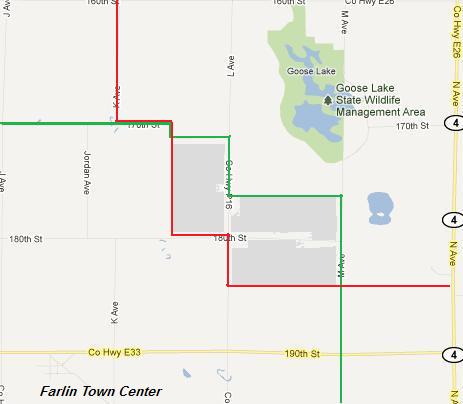
Tensions
in northern Greene County are running high, as the residents of the
Goose Lake area have filed a challenge in the circuit court, challenging
the century-old city limit boundary claimed by neighboring Farlin. As
you can see by the map at left, Farlin's current boundary is indicated
by the green line, and the Goose Lake claim by a red line. The gray area
between is the disputed area. The territorial abstract indicates
that this boundary was first platted in the 1890's.Goose Lake's claim is based on the contention that the original boundary was not drawn based on standard, acceptable surveying techniques. When one reads the original abstract, the "surveyor" who performed the survey was not a surveyor at all, and was the mayor of Farlin at the time. He writes that he merely "eyeballed" the landscape briefly on horseback, then drew up the boundary later at home.
"Us Goose Lake folks are getting really tired of that snooty attitude the Farlin folks have," stated Goose Lake resident Walt Jepke. "Every one of them you meet just thinks they're better than everybody else." Jepke went on to describe various incidents in which Farlin has let the disputed land devalue, arguing that Goose Lake would be happy to perform basic upkeep on it were they to be awarded the land in dispute.
In initial documents presented to the court, Goose Lake argues that Farlin was never intended to be an incorporated area at all, and that the map was merely indicating the placement of a "far line" designating the edge of the map. The name "farlin" was adopted due to a misspelling.
Rick Bland, contributor